Hello, all! I hope that you are well. I have been riding out this most recent storm in town instead of on trail. I have also been working on joining the 3,000 Miles for Peace team at On Earth Peace. I'll post more about it soon. Until then, check it out. Give some money!? Thanks!
3/26/13
3/20/13
3.6.13
Zero day at Tri-Corner Knob Shelter
Chapin woke up this morning at 5:30 and started to break camp. At 7:00 I woke up and started to pack up. It was so cold that our boots had frozen and it took us about 20 minutes to force our feet into them, which is not comfortable. At 9:00 we were both ready to venture out. It had snowed about 2 feet overnight. We hiked about 0.3 miles through hip deep snow drifts before we decided that going 7 miles in this snow would be unsafe today. We turned around and went back to the shelter. We again set up camp and again tried to get warm and dry. It was nearly impossible. I boiled water on my camp stove, poured the boiling water into my Nalgene bottle and took it with me into the sleeping bag inside my tent in the shelter. Still I shivered. I didn't get out of my sleeping bag for 13 hours during the day. Then I got up, did my night-time routine and went to sleep, bottle of boiling water in hand. It was miserable. I was thankful that Chapin was there so I wasn't there alone. But it was a little bit scary.
**Spoiler Alert** I am in Johnson City, TN today, March 20. Safe and dry. (And Chip is here! So I'm not hiking alone anymore! So no more worrying in the peanut gallery. :) )
3/19/13
3.5.13
From Peck's Corner Shelter to Tri-Corner Knob shelter
5.1 miles
Today we woke up and it was cold. Very cold. Chapin Lara and I hiked 5 miles in the rain and I decided that I needed to stop at the shelter and try to get warm. I was afraid that I was too tired to keep hiking the next 7 miles to the next shelter, knowing that it would mean hiking after dark for a second night in a row. Chapin Lara, thankfully, decided to stop also. We found out later that on January 16, about six weeks ago, a hiker was found at the Tri-Corner Shelter, after dying from Hypothermia. But we did not know that when we stopped there.
My camera became water logged today. So sadly I have no pictures.
3/18/13
3.4.13
From Newfound Gap to Peck's Corner Shelter
10 miles
At 7:00 this morning I started calling every shuttle service in Gatlinburg. It took until 9:30 to arrange a pick-up for 10:30 for me and Chapin Lara. I walked to the Subway to buy breakfast and lunch and met Chapin at 10:30 to catch the ride. It took 30 minutes to drive up to Newfound Gap. I am glad that I did not try to hike up the road when it was closed. We crossed Charlie's Bunion today, it was a gorgeous lookout. I am so thankful to be in the Smokies in the beauty of winter. There was a lot of snow, but we made it to the shelter. I hiked about an hour after dark, but arrived safely.
Me and Chapin Lara starting out at Newfound Gap

Snow crusted tree at Newfound Gap

Me at Charlie's Bunion

View from the trail

Trail

Look at the snow vertically off these trees!

View from the Trail


View from the Trail

3/17/13
3.3.13
I woke up this morning ready to hike, but the road is still closed. So instead I took a leisurely morning and while walking through town I found two tickets to the Ripley's Aquarium of the Smokey's! So I went to the aquarium for the day. The big attraction at the aquarium is a moving sidewalk that takes you through a tunnel around and above which are fish and sharks. It was fun. On the way back to the hotel afterwards I ran into Chapin Lara at the KFC. It was the first that I knew he was in town. We decided to try to leave town in the morning.


Spiny fish. See the fake white round eye below the much larger grey real eye?

Of course, seahorses.

Sharks swimming above me in the tunnel

Cool brown striped fish

And of course, jellyfish

3/16/13
3.2.13
This morning I was ready to go hiking again, but the road is still closed. So, another day in Gatlinburg. I found a good Chinese food restaurant and read all of Madeline L'Engle's book A Wrinkle In Time. As I was finishing the book someone walked through with advertisements for Sweet Fanny a theater in Gatlinburg whose opening show is tonight. So after eating I went out for a show. It was disappointing at best, but they really tried. Tomorrow- hiking!


Gatlinburg has a good Trolley system, but unfortunately it isn't in full season yet.

The background on stage at the Sweet Fanny Theater

One of the best acts was this three-legged guy

3/15/13
3.1.13
I had planned to take today as a zero day to explore Gatlinburg, because I have never been here before. So I slept in and wandered the streets, people watching. It was a relaxed day in which I purchased small things I need to keep hiking. I was also informed that the road to Newfound Gap is still closed today, so it is a good thing I hadn't planned to go hiking today. I ended up spending four hours in the Hilton using the computer. Thank you, Afton!

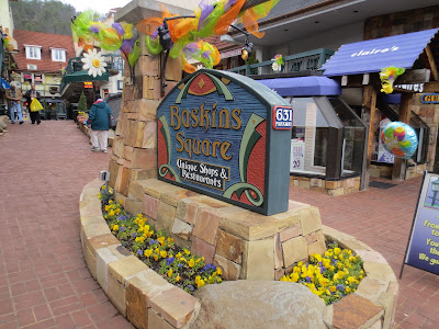
Main Drag of Gatlinburg with the Space Needle in the background.

This made me laugh- the sign that says "Unique Shops" touching a Claire's store.

3/14/13
2.28.13
From Mt. Collins Shelter to US 441/ Newfound Gap
4.5 miles-very very cold and about two feet of snow
This morning I woke up to even more snow. I had slept with my water bottle in my sleeping bag with me and it wasn't frozen, so I was thankful for that. Jack Rabbit left early and I slept in because I knew that I only had 4.5 miles to go to the road. At 10:30 I left the shelter and Chapin Lara was still packing up. At first I was frightened because I knew that I had finished eating all of my food. I was afraid that I could get to the road and there would be no traffic, just like at Clingman's Dome. I knew it would be a 15 mile walk down the road to town. I tried to use my cell phone to call for a taxi, but there was no signal. I learned a few days ago that if there is signal but the phone won't work sometimes you can use body heat to warm it up and then it will be able to work. It's a good trick to remember, but today there was enough storm that I still couldn't get a call through. For the first mile I chanted "safely, forward" to myself in a sort of rhythm to keep myself moving forward and not too worried. By the second mile I was feeling pretty good. Not warm, exactly, but good.
When I reached the road at 2:30 there was absolutely no traffic. I started to take pictures while I thought about what I would do. Just then, I mean I had been at the road maybe three minutes, a park ranger pulled up in his truck. He offered to give me a ride all the way to town. I gratefully accepted. He informed me that within a mile of where we were there had been a landslide six weeks ago that took 100 yards of road 1/2 a mile down the mountain. He told me that work to rebuild it had begun today. The road is a major thorough fare between Gatlinburg, TN and Cherokee, NC. However, because of the landslide the road effectively dead ends now from Gatlinburg to the trail. On a good day there is little traffic there, but today there was ice on the road so the park service had closed it completely. Even if I had been able to call a taxi it would not have been able to reach me. Wow.
I didn't know this at the time, but later I found out that Chapin Lara had arrived at the road crossing about 90 minutes after me. He was able to call his daughter in CA and tell her where he was and ask that she arrange for a cab ride for him. He did not know the road was closed. He started hiking down the road. After eleven miles a police car pulled up and told Chapin that his daughter had called them when she found out the road was closed. The police took Chapin to a hotel, but (he felt) not until after they had given him the third degree of interrogation about what he was doing and whether he was carrying any weapons. But he arrived safely in Gatlinburg, finally.
The ranger that gave me a ride to town also told me about the wild hogs that are in the park. Apparently in the 1950s a hunting sports place imported the hogs from Prussia and they got loose. They have no natural enemy in these woods and can be large and aggressive. The park hires between two and three full time rangers each year with the express purpose of killing the hogs in the park to attempt to maintain a stabilization of the population. Fifteen miles later he dropped me off at the edge of town. I ate and checked into a hotel for the night.
The hotel owner is a very conservative Christian man who felt it necessary to tell me, five minutes after we met, that the reason God sent the floods and hurricanes to the East Coast last year and also Super storm Sandy was because the East Coast states have legalized gay marriage. He had many many other things to say as well, but as I hope that you enjoy your dinner tonight I will not repeat them all here. Needless to say I do not feel comfortable in the hotel lobby, and have plans to spend tomorrow out and about in Gatlinburg. However, the room is an affordable price, so I can't complain there.


Next to this bridge of sorts was a sign that read "Beech Forest Exclosure This is one of approximately 20 special sites that have been identified for fencing against the wild hog, a non-native animal that has been present in the park only since the 1950s. This exclosure contains a beech forest community that is unique to the Southern Appalachians. It contains an assemblage of native plants and animals that would be seriously impaired by the invasion of hogs. The fence was installed in 1984 in an effort to retain the natural character of the site."


4.5 miles-very very cold and about two feet of snow
This morning I woke up to even more snow. I had slept with my water bottle in my sleeping bag with me and it wasn't frozen, so I was thankful for that. Jack Rabbit left early and I slept in because I knew that I only had 4.5 miles to go to the road. At 10:30 I left the shelter and Chapin Lara was still packing up. At first I was frightened because I knew that I had finished eating all of my food. I was afraid that I could get to the road and there would be no traffic, just like at Clingman's Dome. I knew it would be a 15 mile walk down the road to town. I tried to use my cell phone to call for a taxi, but there was no signal. I learned a few days ago that if there is signal but the phone won't work sometimes you can use body heat to warm it up and then it will be able to work. It's a good trick to remember, but today there was enough storm that I still couldn't get a call through. For the first mile I chanted "safely, forward" to myself in a sort of rhythm to keep myself moving forward and not too worried. By the second mile I was feeling pretty good. Not warm, exactly, but good.
When I reached the road at 2:30 there was absolutely no traffic. I started to take pictures while I thought about what I would do. Just then, I mean I had been at the road maybe three minutes, a park ranger pulled up in his truck. He offered to give me a ride all the way to town. I gratefully accepted. He informed me that within a mile of where we were there had been a landslide six weeks ago that took 100 yards of road 1/2 a mile down the mountain. He told me that work to rebuild it had begun today. The road is a major thorough fare between Gatlinburg, TN and Cherokee, NC. However, because of the landslide the road effectively dead ends now from Gatlinburg to the trail. On a good day there is little traffic there, but today there was ice on the road so the park service had closed it completely. Even if I had been able to call a taxi it would not have been able to reach me. Wow.
I didn't know this at the time, but later I found out that Chapin Lara had arrived at the road crossing about 90 minutes after me. He was able to call his daughter in CA and tell her where he was and ask that she arrange for a cab ride for him. He did not know the road was closed. He started hiking down the road. After eleven miles a police car pulled up and told Chapin that his daughter had called them when she found out the road was closed. The police took Chapin to a hotel, but (he felt) not until after they had given him the third degree of interrogation about what he was doing and whether he was carrying any weapons. But he arrived safely in Gatlinburg, finally.
The ranger that gave me a ride to town also told me about the wild hogs that are in the park. Apparently in the 1950s a hunting sports place imported the hogs from Prussia and they got loose. They have no natural enemy in these woods and can be large and aggressive. The park hires between two and three full time rangers each year with the express purpose of killing the hogs in the park to attempt to maintain a stabilization of the population. Fifteen miles later he dropped me off at the edge of town. I ate and checked into a hotel for the night.
The hotel owner is a very conservative Christian man who felt it necessary to tell me, five minutes after we met, that the reason God sent the floods and hurricanes to the East Coast last year and also Super storm Sandy was because the East Coast states have legalized gay marriage. He had many many other things to say as well, but as I hope that you enjoy your dinner tonight I will not repeat them all here. Needless to say I do not feel comfortable in the hotel lobby, and have plans to spend tomorrow out and about in Gatlinburg. However, the room is an affordable price, so I can't complain there.
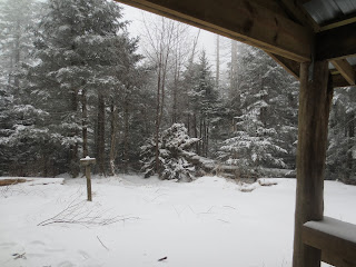
View from the shelter this morning.

Trail


I did not use the black and white setting on this picture, it was this snowy and icy today.

Next to this bridge of sorts was a sign that read "Beech Forest Exclosure This is one of approximately 20 special sites that have been identified for fencing against the wild hog, a non-native animal that has been present in the park only since the 1950s. This exclosure contains a beech forest community that is unique to the Southern Appalachians. It contains an assemblage of native plants and animals that would be seriously impaired by the invasion of hogs. The fence was installed in 1984 in an effort to retain the natural character of the site."

The empty road where the ranger picked me up.

3/13/13
2.27.13
From Derrick Knob Shelter to Mt. Collins Shelter
13.5 Miles including Clingman's Dome
This morning I woke up to snow on the ground and more snow flurries all around. It was cold. And it was beautiful. The day hikers who had warned me about the storm had also told me that I could get off trail at Clingman's Dome. Clingman's Dome is the highest point on the A.T. and is a major tourist attraction. What they didn't tell me was that it is closed in the winter to car traffic. This made it really cool to see, because the only people who can see it in the winter have to hike to it. But it also meant that when I got to Clingman's Dome it was obvious that I wasn't going to get a ride to town like I had hoped. Instead I had to hike another 4.5 miles to the next shelter.
Jack Rabbit left very early this morning, and I left the shelter before Chapin Lara, so I hiked alone until Clingman's Dome. There Chapin Lara caught up to me and we agreed to stick together until we arrived at the shelter. I am very thankful for this because we finished the last two miles in the dark and it was very slippery and a little bit scary. Chapin Lara fell and broke his trekking pole, so I lent him one of mine until we reached the shelter. It was snowing so much that it was difficult to see with our headlamps. Chapin Lara ran out of water, so he drank some of mine. Eventually, at 8:15, we arrived at Mt. Collins shelter to find Jack Rabbit there and comfortably asleep. It really helped today to have his footprints to follow to stay on the trail.
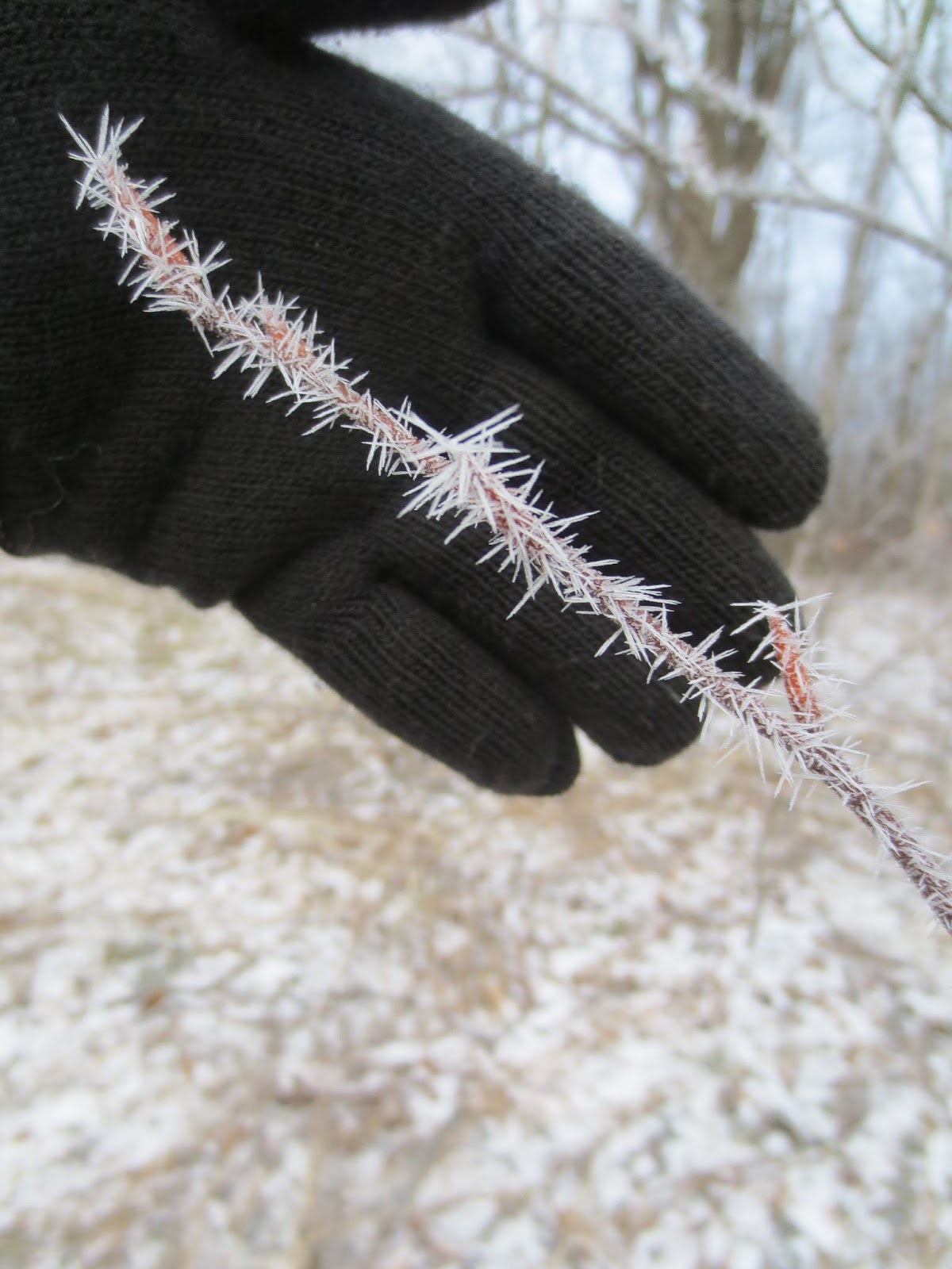
Ice formations on a twig and leaves


13.5 Miles including Clingman's Dome
This morning I woke up to snow on the ground and more snow flurries all around. It was cold. And it was beautiful. The day hikers who had warned me about the storm had also told me that I could get off trail at Clingman's Dome. Clingman's Dome is the highest point on the A.T. and is a major tourist attraction. What they didn't tell me was that it is closed in the winter to car traffic. This made it really cool to see, because the only people who can see it in the winter have to hike to it. But it also meant that when I got to Clingman's Dome it was obvious that I wasn't going to get a ride to town like I had hoped. Instead I had to hike another 4.5 miles to the next shelter.
Jack Rabbit left very early this morning, and I left the shelter before Chapin Lara, so I hiked alone until Clingman's Dome. There Chapin Lara caught up to me and we agreed to stick together until we arrived at the shelter. I am very thankful for this because we finished the last two miles in the dark and it was very slippery and a little bit scary. Chapin Lara fell and broke his trekking pole, so I lent him one of mine until we reached the shelter. It was snowing so much that it was difficult to see with our headlamps. Chapin Lara ran out of water, so he drank some of mine. Eventually, at 8:15, we arrived at Mt. Collins shelter to find Jack Rabbit there and comfortably asleep. It really helped today to have his footprints to follow to stay on the trail.
The ice formations when I woke up this morning were absolutely breathtaking. All day I thought of the quote one of my friends has in her e-mail signature- "There are only two ways to live your life. One is as though nothing is a miracle. The other is as though everything is a miracle." More than once I found myself moaning from the absolute beauty around me.
Ice formations on a twig and leaves

Trail


The white at the bottom of the frame are other iced trees, beyond that the dark is mountains, the lighter blue is clouds, then the sky at the top of the frame.

View from Clingman's Dome-the Highest Point on the A.T.

Clingman's Dome. There is a parking area 1/2 a mile away down a paved sidewalk, so this whole part of the park is wheelchair accessible, which is pretty cool.

Trail

View from the A.T.

Icy trail coming down from Clingman's Dome.

3/12/13
2.26.13
Zero day at Derrick Knob
I woke up at 2:30 this morning to a fantastic rain storm. At 6 it was still going strong, at 9:30 I decided to get up and eat breakfast and it was still raging. Chapin Lara and I decided that if it cleared by noon we would move to the next shelter, but otherwise we would just stay where we were and stay dry. It was an enjoyable day of napping and reading. At 3:00 we were still hedging about wether or not to move on. We decided to build a fire instead. Chapin Lara is a well educated, highly successful business man. An outdoorsman he is not. Yet. But after an hour and after sacrificing his Georgia trail map for kindling, we started a very successful fire. Just before dark a hiker named Jack Rabbit showed up. He had hiked all the way from Fontana Dam today. We were very impressed. He is a white guy from Columbus, Ohio and speaks fluent Chinese.


I woke up at 2:30 this morning to a fantastic rain storm. At 6 it was still going strong, at 9:30 I decided to get up and eat breakfast and it was still raging. Chapin Lara and I decided that if it cleared by noon we would move to the next shelter, but otherwise we would just stay where we were and stay dry. It was an enjoyable day of napping and reading. At 3:00 we were still hedging about wether or not to move on. We decided to build a fire instead. Chapin Lara is a well educated, highly successful business man. An outdoorsman he is not. Yet. But after an hour and after sacrificing his Georgia trail map for kindling, we started a very successful fire. Just before dark a hiker named Jack Rabbit showed up. He had hiked all the way from Fontana Dam today. We were very impressed. He is a white guy from Columbus, Ohio and speaks fluent Chinese.
Me in my tent, trying to stay warm in my sleeping bag.

Chapin Lara in front of his fire.

3/11/13
2.25.13
From Mollies Ridge Shelter to Derrick Knob Shelter
13.5 Miles
Cloudy and chilly
I left the shelter this morning before Chapin Lara and didn't see him until he reached the shelter tonight. I passed two day hikers who told me that they had seen weather forecasts expecting rain all of tonight with 70 mile an hour winds. The day was windy and cloudy, but I stayed dry.
View of the Smokies from trail


Trail


We saw evidence of many mice in the shelter, and it was getting cold, so I decided to set up my tent inside the shelter. Chapin Lara took the sleeping platform above me. We were the only two people in the shelter.

The outside of the Derrick Knob Shelter


**Spoiler Alert! I am in Hot Springs, NC tonight, March 11. Many many people have commented that because of the delayed nature of these posts it is hard for them to know where I actually am in the world. In addition to responding to e-mails as soon as possible, I will start adding spoiler alerts to blog posts when I can to try to begin to address this problem.
3/10/13
2.24.13
From Fontana Dam Marina to Mollies Ridge Shelter
10.7 miles
Today is notable because it begins the trek into the Smokey Mountain National Park. The park contains 72 miles of the Appalachian Trail. I plan to get off in the middle and stay in Gatlinburg, TN for a day.
Chapin Lara and I hiked together today. We took it slow and steady. It was 60 degrees and beautiful. Chapin Lara developed some pretty severe blisters since starting on the trail two weeks ago at Springer Mountain, so he had taken four days off at the hostel. Today was his first day back at it and his feet were still painful.
This shelter is called the Fontana Hilton because there are free heated bathrooms and showers in a nearby building.

A view of the Fontana Dam waters

The dam on the right

After hiking for three miles we reached a fire tower. Jeff had told us to absolutely not miss the opportunity to see these views. So I hiked on up while Chapin Lara took a break.


Me taking a break

Chapin Lara in the shelter. Notice the skylight, the fireplace all the way at the end, and the fact that the sleeping platform above Chapin Lara's head doubles the available sleeping floor space. We were the only two hikers at the shelter.

As I gathered water tonight from this pipe in this stream I remembered again how I live in luxury that this way of gathering my drinking water is by choice, and not a daily chore.

Subscribe to:
Posts (Atom)